
Map of Japan
Map of Japan > Japan Locator Map • Japan Travel Tips • Japan Relief Map
Japan Map, Showing Major Cities and Islands
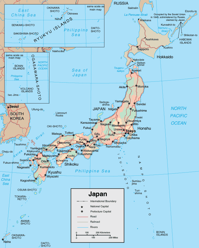
Geography of Japan
Japan's topography has been made very interesting by complex folding and faulting patterns. Because of this, you can find small basins and coastal lowlands alternating with mountains and treed hills. The landform patterns have also been affected by volcanic cones and calderas. Today, Japan has about 150 volcanoes, 60 of which are still active. Fuji-san, the highest mountain in Japan, is a dormant volcano that hasn't erupted since 1707. Most people in Japan live on the coastal plains, and the mountainous regions are sparsely populated.In addition to volcanic eruptions, earthquakes and small tsunamis are common because Japan sits atop continental plates that are constantly shifting and moving. The complex land patterns also affect Japan's wind and weather patterns, which can be turbulent and unpredictable.
Japan's Climate
Japan's latitude stretches from 25 degrees North to 45 degrees North, so the climate varies widely in Japan. The north has cold, snowy winters, with temperatures sometimes falling close to zero degrees Fahrenheit. Summers are warm, with temperatures commonly reaching almost 90 degrees Fahrenheit. While rain falls in all seasons, Tokyo has more rainfall and higher temperatures than the southern islands.
Leading Japanese Cities
The energetic city of Tokyo bustles with a fast-paced consumer culture, contrasted by traditional quiet and calm themes. Osaka, a down-to-earth industrial city situated on the southwest coast of Honshu island, features an active and important port, hearty cuisine, and a variety of tourist attractions. Kyoto, located in southwestern Honshu, was the imperial capital for over 1,000 years, and it is the cultural center of Japan.
Japan Travel Information
Tokyo is the world's largest city, with a 2005 estimated population of 35,327,000. The Tokyo National Museum displays Japanese art, and on Hokkaido island, visitors enjoy the rugged Daisetsuzan National Park. Japan is home to the sobering historical sites of Hiroshima and Nagasaki, where atomic bombs exploded during World War II. At 12,388 feet high, Japan's tallest elevation is the volcanic Mount Fuji, which many Japanese people view as a sacred place. For more extensive information about Japan, visit Web Japan.
Japanese Tourism
- Japan National Tourist Organization - Japanese government site providing information for online budget hotel reservations, regional guides, convention locations, museums and important starting information.
Japan Resources
- CIA - The World Factbook - Japan - US Government almanac offers maps, geography, and statistics about Japan.
- Wikipedia - Japan - includes information about Japanese history and the regions and geography of Japan.
- Japan News - News headlines and news article links about current events in the nation of Japan.
Related Asia Map Websites
- Map of China - Chinese travel information.
- Map of Russia - Russian travel information.
All rights reserved. About us.
Certain maps hereon are © Map Resources.